|
In the heart of the Jerusalem Hills, on
the eastern slopes of Mount Eitan on the western approaches to Jerusalem,
green slopes drop down to the Sorek Riverbed. Two springs flow from
the mountain, irrigating agricultural terraces - a reminder of the ancient
Hebrew culture, dating back thousands of years, which was almost lost
to the world. Here, exactly as in the time of the Israelites, vegetable
gardens are irrigated and fruit gardens, not needing irrigation - olive
groves, almond trees and vineyards - are cultivated. The landscape looks
green and fresh all year round. This is Sataf, a corner of hidden beauty,
where time seems to have stood still.
|
|
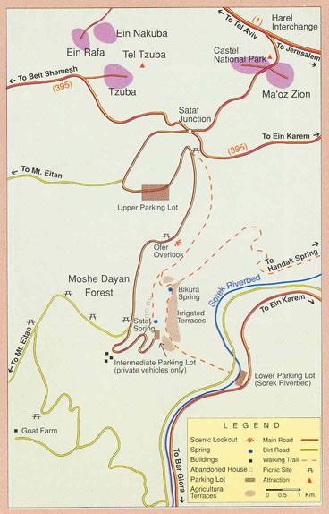
Three routes can reach Sataf:
1. Turn south off the main highway to Jerusalem (Rt. No.1) at the Harel
Exit and continue south through Maoz Zion toward Kibbutz Tzuba (Rt.
3965).
2. From Jerusalem, take Rt. 395 from Ein Karem, in the south-west part
of the city.
3. From the coastal region, the very same road can be taken, but from
the opposite direction: from Eshtaol Junction via Kissalon, Ramat Raziel
and Tzuba.
From Sataf Junction, a partially paved road leads down to Sataf. From
the Nahal Sorek highway at the foot of the site (Rt. 386), there is
a marked trail for hikers.
|
|
The entrance to the site is from Sataf
Junction, where the roads coming from Mevasseret Zion, Kibbutz Tzuba
and Ein Karem meet. At the beginning of the access road is the upper
parking lot; a little further on, at the entrance to the site itself,
is the intermediate-level parking lot, for private vehicles only. If
time permits, it is best to walk from the upper parking lot. The path,
which follows an ancient route winding among olive groves and cultivated
plots, leads down to Ofer Overlook, which offers a marvellous view.
The ruins of abandoned Sataf are clearly visible, and the path continues
on to the village. Below the olive groves excavation is in progress
on a Chalcolithic village (circa 4,000 BCE), the oldest agricultural
traces found in the region.
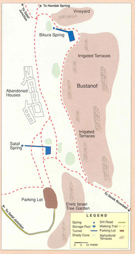
From here make your way to the Sataf Spring (Ein Sataf), which was the
main one in the village. From the terrace above the pool, you may carefully
descend to the cave from which the spring issues. The cave was partially
quarried out of the rock to increase the water supply, and a tunnel
was built to convey the water to the large pool, which has a capacity
of some 180 cubic meters. You can walk, stooped, through the tunnel
and exit at the other side. A small room is built into the back wall
of the pool, where the village women apparently did their washing.
A marked path leads from the pool to the irrigated plots.
The tunnel outlet of the Sataf Spring is at the terrace on the left.
Man-made plastered channels conduct water to the plots, using different
devices to overcome the varying terrace heights. If you leave the leftward
path to the irrigated plots, and turn right instead, you come upon a
high stone wall with an Iron Gate. Behind it is the Eretz Israel Tree
Garden, where fruit trees of the original strains known in the country
are cultivated by traditional methods. From here you return to the irrigated
plots, where vegetables and herbs are in beds or in furrows - all organically.
Below the irrigated plots are the cultivated terraces of the where JNF
enables those who so desire to raise small gardens as a hobby.
From the irrigated plots you can proceed to the Bikura Spring (Ein Bikura).
En route you'll see hanging stairs on the terrace wall, an efficient
way to save on precious ground. From here, too, you walk through the
tunnel to the cave, this time without stooping. cave contains stalactites
and stalagmites.
The path up from the Bikura Spring has been restored as traditional
mountain trail. Beside it, enclosed by stone walls gates, a vineyard
has been planted and uses roof, pole, and trailing methods.
Further on, you may take the path back to the upper parking. From this
point you may also set out on an ancient path down to Handak Spring
(Ein Handak). Other options are to return to the Sataf Spring via the
remains of Sataf village and, from there, descend to the lower parking
lot in the Sorek Riverbed (Nahal Sorek ). Make sure you have a vehicle
waiting for you there, or make your way the intermediate-level parking
lot, if that is where you've left your car.
|
In
1949 Moshav Bikura was founded on the ruins of Sataf, an Arab village abandoned
during the War of Independence. Before long the new residents, too, had to leave
and, in time, the supporting walls collapsed and dirt and debris covered the
two storage pools and the conduits bringing spring water to them.
In the early '80s Keren Kayemeth Lelsrael-the Jewish National Fund undertook
the renovation of the agricultural terraces in the area. It restored the storage
pools of the Sataf and Bikura Springs, repaired the terraces and redug the irrigation
channels. As a result, biblical hillside agriculture can once again be seen
in action and, in the future, ancillary industries will also be on view - such
as olive pressing for oil, grape treading for wine, etc.
The ongoing restoration work is being carried out in part by pupils and soldiers
who thus come face to face with concepts straight out of Jewish sources: "a
sealed well," "irrigated agriculture" and "dry farming."
JNF employs two families who live at Sataf and handle the restoration work,
cultivate the fruit and vegetable gardens, and guide visitors around the site.
Visitors can enjoy not only seeing the site in action, but also the nearby forests,
which extend over some 6,000 dunams (a dunam is 1/4 of an acre or 1/10 of a
hectare).

|
Sataf's Bustanof project, named from the combination
of the Hebrew words for "fruit garden" and "scenic view,"
is unique in Israel. For a nominal fee, JNF enables Jerusalemites to
cultivate small plots for their enjoyment in their spare time - a break
from daily routine that lets them breathe in "mountain air as clear
as wine" and relive the passage: "each man under his own vine
and fig tree."
|
In the Israelite period, our forefathers found that the
veteran local population already occupied the easily workable lands in
the valleys. They were thus left with rocky ground and natural forests
in the Judean Hills and southern Samaria: "Go up to the forest and
clear ground for yourselves" (Joshua 17:15). A good deal of labour
went into clearing the rocks (described in the Bible as izuk) and removing
them to the edges of the natural terraces (sikul). These stones were then
used to build supporting walls for a layer of fertile soil imported to
the area. This is how the agricultural terraces were constructed, the
word "terrace" deriving from the Latin word "terra"
for "land."
The leftover stones from izuk and sikul were used to build watchtowers
to guard the crops. Their construction is described vividly in the Parable
of the Vineyard: "My beloved had a vineyard on a very fertile hill.
He dug it and cleared it of stones, and planted it with choice vines;
he built a watching place in the midst of it, and hewed out a vineyard
in it" (Isaiah 5). The terraces and "watching places" thus
became part of the landscape of the Judean Hills and of Jerusalem.
A prototype vineyard as described in the parable has been created at Sataf.
It contains 26 of the ancient types of vine that grew in Eretz Israel,
as well as terraces, mounds of cleared stones and a "watching place."
Nearby are the remains of a wine press for processing the grapes.
|
Most
of the terraces were used for dry farming, relying solely on rainfall. In the
Judean Hills, the chief produce consisted of vines, olives, figs and pomegranates.
In the few places that had water, larger terraces were built on several levels
in order to make the most of the rare opportunity to raise different crops all
year round through irrigation. It was exhausting work, yielding only limited
arable land. Crops were maximised by building the terraces as close as possible
to natural springs.
Since the springs did not supply a great deal of water, the early inhabitants
expanded their supply by tunnelling into the water- bearing strata. The water
was then stored in large pools and conducted via a system of channels to the
terrace plots. Tunnelled springs thus came to be an integral part of the terrace
systems in the Judean Hills. The Song of Songs (4:12) refers to them individually
as "a locked garden, a sealed well."
A village near a spring was built above it, of course, so as not to waste any
land that could be irrigated through the force of gravity. The irrigated terraces
below the spring produced several harvests a year.
"Of
all the lands there are for dismal scenery, I think Palestine must be the prince."
So wrote Mark Twain during his visit to the county in 1870.
Today this same land is blanketed in green, of which some 1.2 million dunams
of forests and natural woodlands are tended by Keren Kayemeth lelsrael.Jewish
National Fund. The arid landscape has been rolled back and replaced by plants.
Hundreds of thousands of dunams have been reclaimed and rehabilitated, once
more offering residents livelihood and welfare. It is hardly possible to imagine
the nation celebrating its holidays without their popular picnics in forests
and nature.
Beyond the rustle of leaves, behind the foliage of green, hides a story. Serialised
and episodic, it spreads over almost a century: the story of KKl.JNF.
KKl.JNF has not stopped planting since the seeding of its first trees at Ben
Shemen and Hulda. At dozens of sites, from Metulla to Eilat, it plants millions
of saplings year in year out foi' a greener future, extending woodlands in the
north and rolling back the desert in the south, while keeping a watchful eye
on forest health.
It has been the executive arm of the Zionist enterprise from its inception.
There is hardly a community in Israel whose lands it did not reclaim, whose
stones it did not clear. The map of Jewish settlement in Eretz Israel prior
to statehood was, to a great extent, determined by KKl.JNF: Hulda, Deganya,
Jezreel Valley, Beit She'an Valley, Hefer Valley, Haifa Bay, the Negev and Galilee
- interlocking links that largely molded the borders of the state-in-the-making.
The basis of KKl.JNF's work is national ownership of land which, in turn, is
based on the biblical injunction that "the land shall not be sold in perpetuity"
(Leviticus 25:2) - a guiding principal that has been borne out time and again,
both in the past and today. Tens of thousands of immigrant homes have been built
on KKL.JNF land. What would have happened had there not been land available?
Formerly, it was necessary to reclaim extensive agricultural tracts to promote
settlement. Today, with the drop in demand for agricultural labour, KKL.JNF
assists rural communities to develop tourism sites as additional, alternative
sources of livelihood: from Timna Park at the edge of the Arava to Tel Maresha,
Beit Govrin and Goren Park on the Lebanese border.
At the same time, it has been increasingly involved in helping to solve Israel's
growing water shortage, as the population burgeons from high rates of both birth
and immigration. Dozens of dams and reservoirs have been built allover the country
in recent years to harvest excess surface runoff, primarily from winter floodwaters:
ranging from Shira and Reshafim in the Beit She 'an Valley to Dalton in Galilee,
the Eshet and Tzukim stow dams in the Arava, the Nirim dam, and the large Besor
reservoirs in the northwestern Negev.
In many countries KKL.JNF serves as the window onto Zionism. It is active in
Jewish education, deepening the bond between diaspora Jewry and Israel; and,
in Israel, as well, it boosts youth identification with the land through varied
and various educational activity at schools, youth organizations and its own
field centers.
In the future, too, KKL.JNF will be breaking new ground. Fallow land will be
turned into choice soil. Barren hillsides will continue to be painted green.
KKL.JNF will keep on rolling back the desert, improving the country's ecological
balance and ensuring a high quality of life and environment for Israel's residents.
It is an unfinished story. A story that cannot be ended.