
|
 |
||||||||
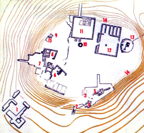
| Legend: 1. The Megiddo Museum, formerly headquarters of the Rockefeller Expedition. 2. Staircase and outer gate in northern section of the city built during the reign of King Solomon (970-930 B.C.E.). 3. The city's northern gate in the days of King Solomon. 4. The city's northern gate in the 15 th century B.C.E. 5.The city's northern gate in the early 18 th century B.C.E. 6.The holy precinct in the 19.20 centuries B.C.E. |
|||||||||
|
7. Remains of temple of the Chalcolithic Period (end of 4 th - beginning of 3 rd millenium B.C.E. 8. Residence of the commander of King .Solomon's Chariots. 9. A building of the period of King David .~ (1006-970 B.C.E.) 10. Public grain silo of the period of Jeroboam Ben Joash, King of Israel (792-752 B.C.E.). 11.Palace of the period of King Solomon. 12.12. King Solomon's "City of Chariots". 13. The city water system (built in the 19th century B.C.E.). 14. Remains of the city wall during the period of the Israelite Kingdom. 15. Observation points. |
|||||||||
| Megiddo southeast of Haifa, lies at the head of a mountain pass at the western end of the valley of Jezreel. Commanding a key defile into northern Israel, and standing astride the great trunk road from Egypt in the south to Syria and Mesopotamia in the north, it was thus a vital strategic site throughout history and the scene of mighty biblical battles. It was an object of fortifications by its occupiers and of attack by contending empires from pre- biblical times right up to the First World War in this century. Small wonder that Megiddo finds frequent mention in 2nd millennium documents and Bible. In the New Testament Book of Revelation,...it is marked as the site of the last great battle of the world: Armageddon (which is a corruption of the Hebrew Har Megiddo). Small wonder too, that the large scale archaeological excavations carried out on that Megiddo tel, or artificial mound between 1925 and 1939 should have brought to light the remains of twenty distinct historical periods, from 4000 B.C.E. to 400 B.C.E. The more spectacular of the ruined structures now visible belong to the fortified "chariot city" built by king Solomon in the 10th century B.C.E. and to its Israelite successors, and to the remains of Hyksos and Canaanite cities. The ancient water system dating from the 9th century B.C.E., preserved to this day and now cleared and made accessible by the Israel Nature and National Parks Protection Authority, is a remarkable piece of engineering. It consists of a large shaft sunk through the rock to a depth of 120 feet, where it meets a tunnel cut through for a distance of 215 feet to a spring outside the city. This ensured the water supply for the defenders in time of siege for the spring, outside the city, was also hidden by a wall camouflaged by covering of earth. Near the centre of the mound is an 8th century B.C.E. sunken grain silo, with a staircase against the circular wall curving down to the bottom. At the southern part of the tel are the ruins of stables, built probably by king Ahab in the 9th century B.C.E., and some of the stone hitching posts and limestone mangers may be seen today. Three Canaanite temples still stand at the eastern edge of the site. The Israel Nature and National Parks Protection Authority, has prepared the entire site for visitors, laid out footpaths and provided explanatory signs for the ruins, so that no guide is necessary. |